The lying pen of the scribes is at it again (Jeremiah 8:8).
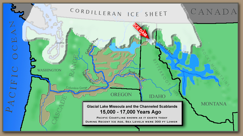
“One such flood” is actually Glacial Lake Missoula.

From the U.S. Geological Survey:
Missoula Floods: With the beginning of the Pleistocene time, about one million years ago, cooling temperatures provided conditions favorable for the creation of great sheets of moving ice. Thus began the Ice Age. At the end of the last Ice Age, a finger of the Cordilleran ice sheet crept southward into the Idaho panhandle, forming a large ice dam that blocked the mouth of the Clark Fork River, creating a massive lake 2,000 feet deep and containing more than 500 cubic miles of water. Glacial Lake Missoula stretched eastward for some 200 miles and contained more water than Lake Erie and Lake Ontario combined. When the highest of these ice dams failed, lake water burst through, shooting out at a rate 10 times the combined flow of all the rivers of the world. This towering mass of water and ice literally shook the ground as it thundered toward the Pacific Ocean, stripping away hundreds of feet of soil and cutting deep canyons -- "coulees" -- into the underlying bedrock. With flood speeds approaching 65 miles per hour, the lake would have drained in as little as 48 hours. Over time the Cordilleran ice sheet continued moving south and blocked the Clark Fork River again and again, recreating Glacial Lake Missoula. Over approximately 2,500 years, the lake, ice dam and flooding sequence was repeated dozens of times, leaving a lasting mark on the landscape.
From NOVA, Mystery of the Megaflood: “From these new findings we can reconstruct just how Glacial Lake Missoula sent two and a half trillion tons of water, nearly half of Lake Michigan, surging across the American northwest.”

